Description
The Vauban circuit takes you through the historic parts of the city of Luxembourg, to the points of strategic importance in one of Europe’s most impressive fortresses.
The circuit bears the name of the famous French military engineer, active during the reign of Louis XIV, Sébastien Le Prestre de Vauban (1633-1707). Appointed commissioner for fortifications at the age of just twenty-two, Vauban built or enlarged more than 160 fortresses in total. When he arrived in Luxembourg with the French enemy troops, the Spanish held sovereignty over the fortified city, which from the Middle Ages onward had been ruled by a number of foreign powers in turn.
Following the traces of Vauban (General Commissioner for Fortifications), you will discover sites that bear witness to Luxembourg’s military past, experience the medieval charm of the old Lower Town of Pfaffenthal and, from the fortified heights, enjoy breathtaking panoramic views of the city. Developed into a federal fortified city during the Prussian era, Luxembourg was deemed impregnable right up until its demolition.
Directions
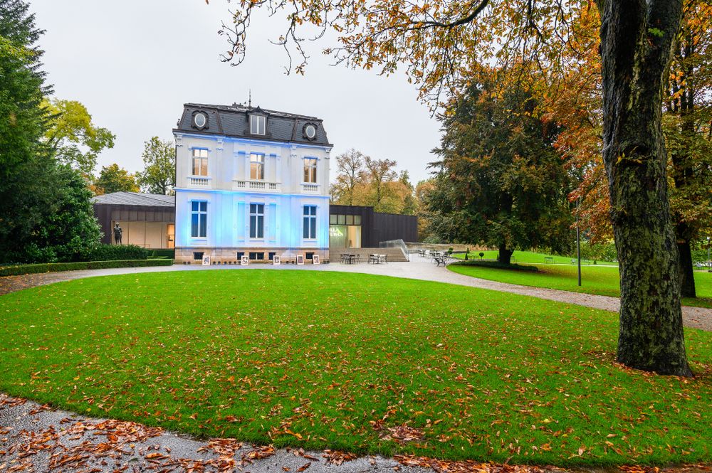
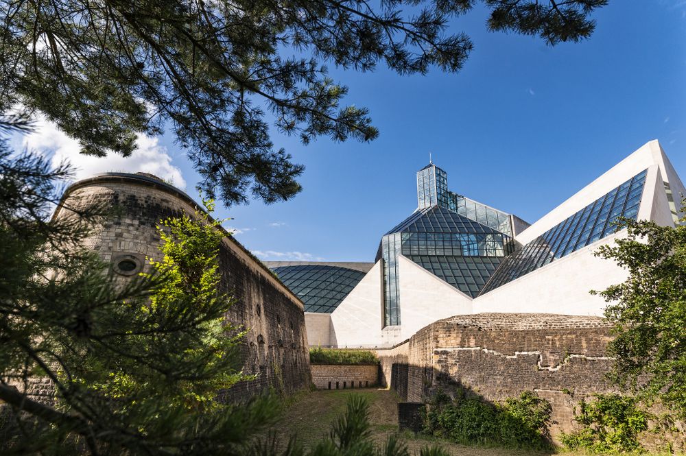
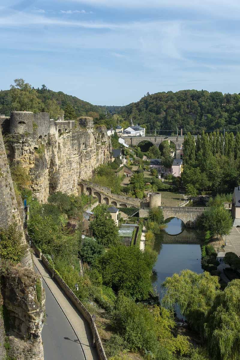
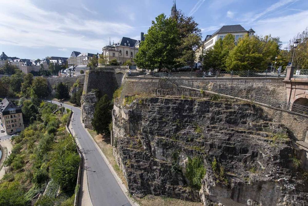
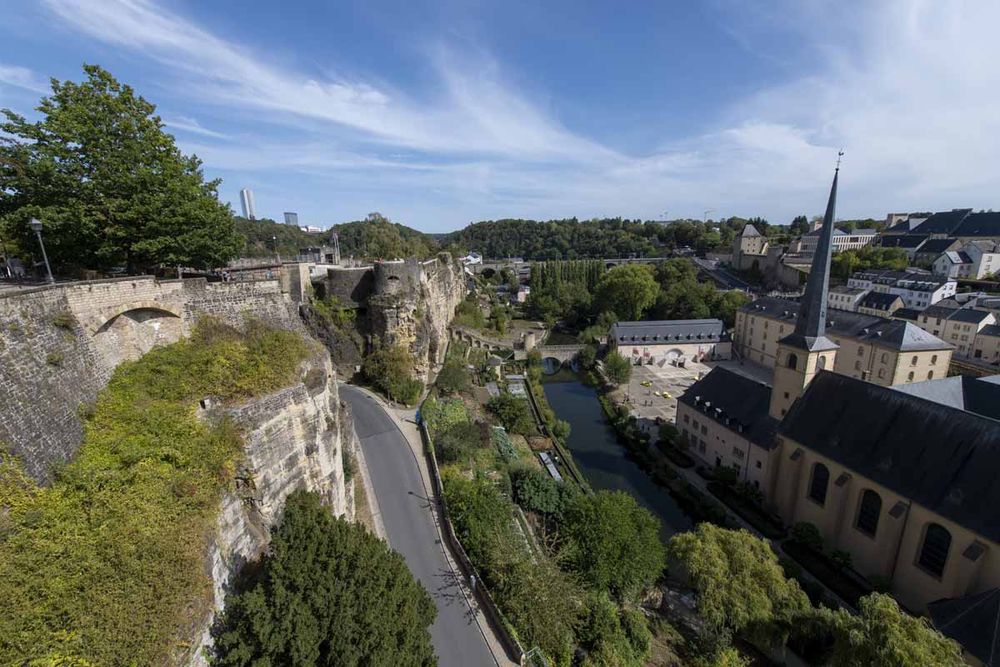
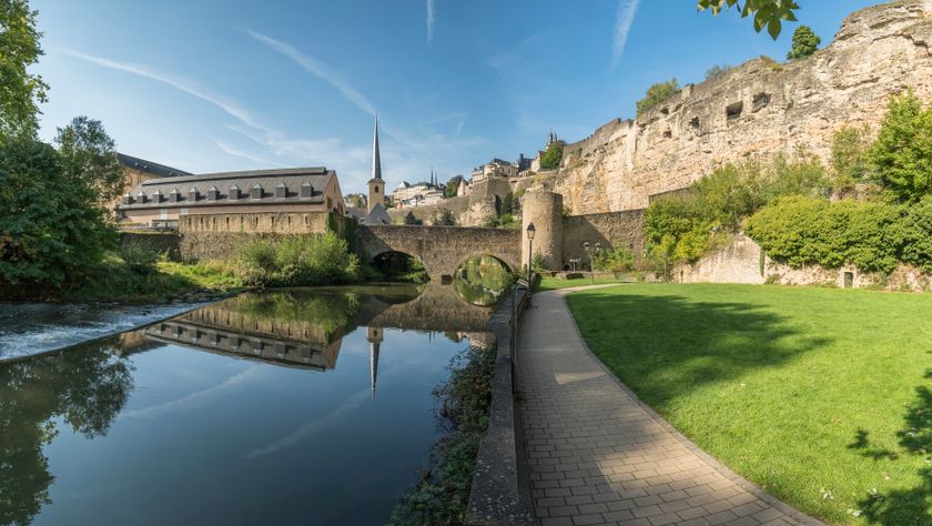
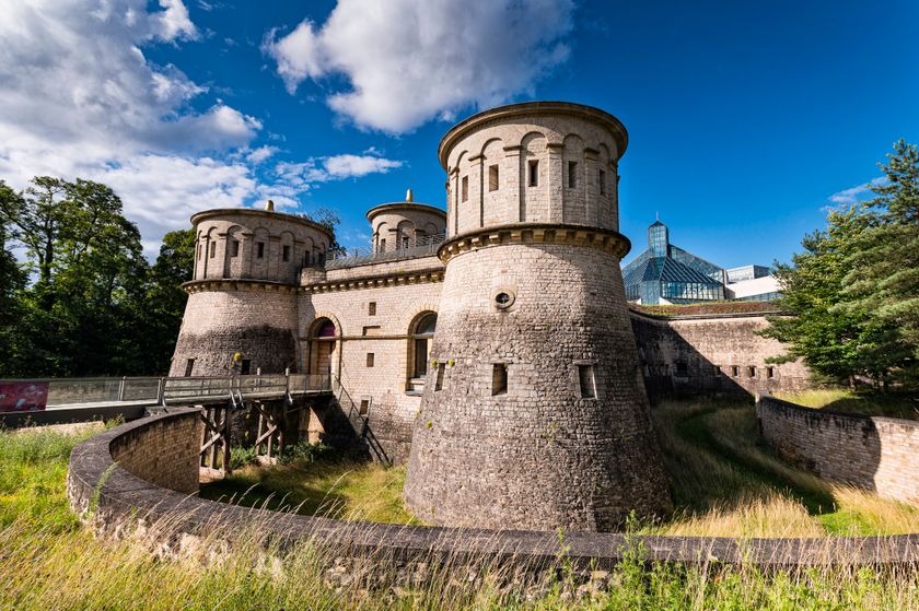
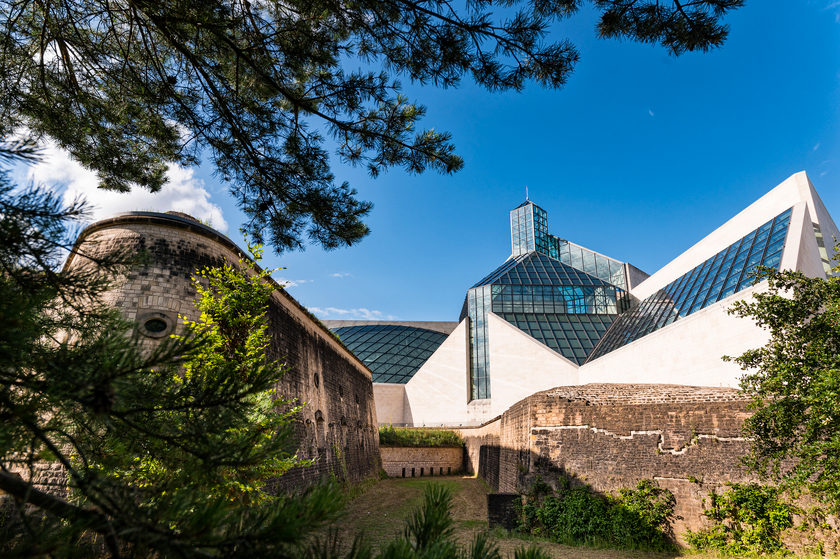
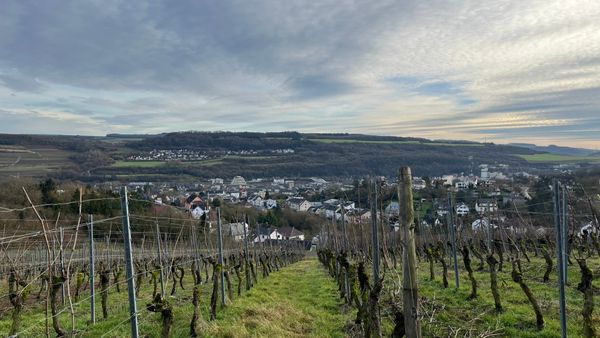
The starting point of the Vauban circuit is the Bock Promontory, a rocky outcrop bounded by steep slopes, whose strategically favourable location was recognised by Count Siegfried when he built his fortified castle here in the 10th century, the origins of what later became the Upper Town. After the castle was destroyed and fell into ruins, the Spanish Habsburgs built the first fort here (completed in 1620); it was destroyed in 1684 when Luxembourg was captured by the French. Subsequently Vauban had the old Bock fortifications restored without too many alterations. It was only later, during the reign of Empress Maria Theresa, that the fort was reinforced with twenty-five gun emplacements, the Bock casemates (1744-45). The Vauban circuit leads across the castle bridge in front of the State Council, continuing behind 19th century houses which now contain various sections of the National Museum of History and Art (MNHA). The entrance to this cultural centre is located alongside the main façades of these patrician houses in a modern building on the old Marché-aux-Poissons. We continue under the arch of Pfaffenthal’s first gate opposite the museum and walk along the Lower Government Bastion (1606), which points upwards to the sky. We leave the medieval fortification ring of the Upper Town through the pointed arches of Three Towers gate. The square central tower dates from the time of the second fortification ring (probably around 1200), while two circular flanking towers were added in the 14th century. Taking the pedestrian crossing to the other side of the road, we are greeted by the panoramic view near one of the many bartizans, commonly known as Spanish watchtowers. We then make our way down the “Montée de Pfaffenthal” into the Pfaffenthal Lower Town, which lines both banks of the Alzette river, and which together with Grund Lower Town forms the city’s oldest district. Here, where the old Roman road linking Reims, Arlon and Trier crosses the Alzette, a small settlement existed during Roman times. In the Middle Ages, craftsmen and modest tanners, brewers and wool-dyers settled in Pfaffenthal, which owes its name to the monks of the Benedictine Abbey in Altmünster, who tilled the earth in this fertile valley. The narrow lanes of this charming district still retain the lively atmosphere of yesteryear. We follow rue Laurent Menager, passing the panorama lift (2016), to reach Pfaffenthal’s famous landmark, the massive, well-preserved Vauban Towers, named after the medieval constructions they replaced: the Eich Gate and the Bons Malades Gate (beyond the Alzette). During the French siege, Vauban identified the largely unfortified Pfaffenthal and the adjacent heights as the fortress’ weak points. Consequently, in 1685 he had these sections incorporated into the fortress. He reinforced the heights with two forts and closed the valley off with a protective wall, which linked Fort Berlaimont on the city side to the new forts on the Grünewald heights opposite. Vauban also strengthened the valley’s defences by erecting two defensive towers there. In addition, deep moats (uncovered 1997-98), heavy drawbridges and loopholes helped to keep the enemy at bay. If the enemy managed to reach a tower nevertheless, the defenders could always pour pitch or boiling oil through the apertures (so called machicolations) in the corbelled walkway. Doors on the first floor opened on to the rampart walkway in the protective walls. In front of the Eich Gate stands a second, arrow-shaped fortified construction, a so-called ravelin, which protected the gate’s moat after 1743. Its surface stonework was demolished in 1872 and recently rebuilt. The slender chimney on the river bank is the remains of a pumping station (1876) which pumped well-water from the valley bottom to the Upper Town. Between the two Vauban Towers, a protective wall spans the river in the form of a narrow bridge, known as “Béinchen” in the vernacular. We proceed along its walkway, which once bristled with parapets and loopholes (partially rebuilt a few years ago) to the opposite bank of the Alzette, access to which could be shut off by means of grates in the three arches of the bridge. From the river bank, we look towards Pfaffenthal bridge, of more recent construction. Further upstream, the foundations of a Roman bridge, the main crossing until the Middle Ages, were unearthed in 1990. From Bons Malades Gate*, we can either ascend directly to Niedergrünewald up a long modern stairway that follows the contours of the historic surrounding wall, or continue our visit along a more gently sloping path without steps, via rue Vauban and rue Trois Glands, known as “Hiel”, which also provides access to Fort Niedergrünewald. * During the touristic season, a film on the history of the city is shown inside. Climbing the steps, halfway between the suburb and Niedergrünewald we meet the Luxembourg–Ettelbruck railway line. The railway entrance to the city dating from 1859 passes through a fortress gate studded with loopholes. At the end of our climb, we reach Fort Niedergrünewald, built by Vauban in 1684-85. Fort Niedergrünewald consisted of three bastions, two ravelins and an extensive network of underground chambers. Following the demolition of the fortifications, a section of the left-hand terraced bastion was preserved. Slightly higher up was the Pfaffenthal Redoubt, a small projecting construction built by Vauban to reinforce the fort in 1688; it was knocked down during more recent construction works. From Fort Niedergrünewald we descend (again) into the “Höhlental” (“valley of caves”), also called “Hiel”. In 1684-85, Vauban had the Grünewald Gate, or “Höhlentor”, built to defend the narrow transverse valley of the Alzette, the route of the old Roman road to Trier (now rue des Trois Glands). Originally reinforced with a moat, drawbridge and a machicolation, this tower was subsequently altered and an extra storey added. The adjacent protective walls were demolished in 1875. The three one-storey flour stores, located slightly below the tower, are almost fully preserved. Above the Grünewald Gate, a narrow forest path takes us up to the heights again. We pass through the remains of Fort Obergrünewald, which we will also pass on our way back, until Fort Thüngen, named after sergeant-general Adam Sigismund von Thüngen. The fort’s remains disappeared after the dismantling in 1876 under a layer of earth. After the Dräi Eechelen site was transformed into a park by landscape architects, it became a place of recreation and relaxation for the local population. The Fort Thüngen, Musée Dräi Eechelen is located in the parc bearing the same name. The name is derived from the three gilded stone acorns crowning the towers of Fort Thüngen reduit. The Austrians built the fortress with its spectacular casemates, galleries and mines in the years 1722-23. It is still largely in its original state dating from the last extension in 1836-37 by the Prussians. The fortress’ and country’s history are interlinked. This historical development is portrayed by more than 600 displayed objects and original documents from the outgoing Middle Ages to the beginning of the 20th century. The permanent and special exhibitions provide us with a general overview of the “Gibraltar of the North” and tell us notable features of the “Luxembourg Fortress”. Since 2018, the exhibition as well as the fort’s casemates can be explored interactively in 3D from home or while on the move. The museum building itself attests in a unique way to the link between past and present. Through a 169-metre-long gallery* carved in the rock, we can walk subterraneously from Fort Thüngen back to Fort Obergrünewald, the latter been built under Vauban after 1684. * This gallery is accessible together with a museum employee during the museum’s opening hours. Visitors are asked to direct themselves to the reception desk at the museum. The remains of this fort were unearthed and partially rebuilt in 2009. Today, the furthermost point of the south-eastern bastion is still guarded by a Spanish bartizan, an old watchtower. The city-side edge of the Fort provides a breathtaking panoramic view of the Upper Town. In the foreground we can see the Bock promontory with its cannon emplacements broken and blasted into the rock (casemates), rendered unusable after 1867 when their apertures were enlarged. The Vauban circuit then leaves Grünewald heights and leads us down to Clausen Lower Town. Here, the Mansfeld Gate (built before 1600 by Count Mansfeld and reinforced in 1684-85 by Vauban) closed off access to the fortress from the north-east. We cross the Alzette and pass under the high arches of the elegant viaduct dating from 1858-61 to reach the Youth Hostel on rue du Fort Olizy. From there, we return to the starting point of our tour along the foot of the Bock promontory.
For your safety
No special safety measure are required but be careful on slippery pavement.
Equipment
No special equipment is required for this tour.
Journey
Use the free public transport to get the bus stop Pfaffenthal, Um Bock or Clausen, Plateau Altmünster with ths buslines 9 & 14.
Getting there:
Follow the signs that lead you to the Bock promotory on Montée de Clausen or indicate Montée de Clausen in your GPS.
Parking:
Parking places for cars can be found in the paralell streets nearby.


 This website uses technology and content from the Outdooractive Platform.