Lee Trail
© Alfonso Salguiero

Outdoors Passion Escapardenne Lee Trail

7 minutes

Walking with friends

Destination(s): Éislek

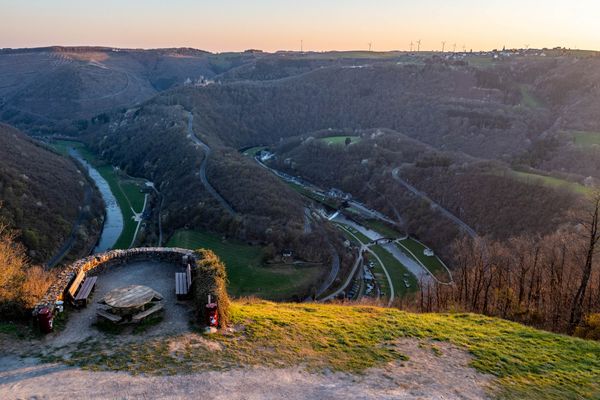
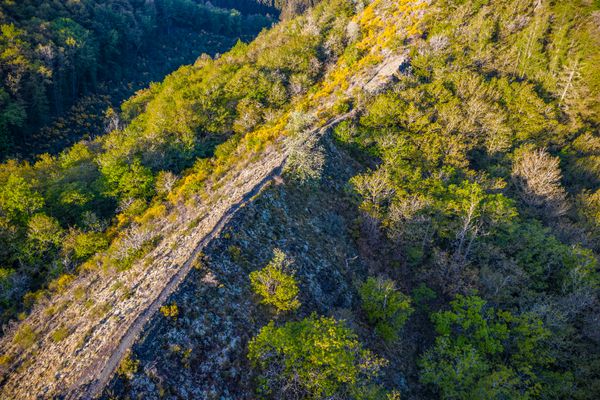
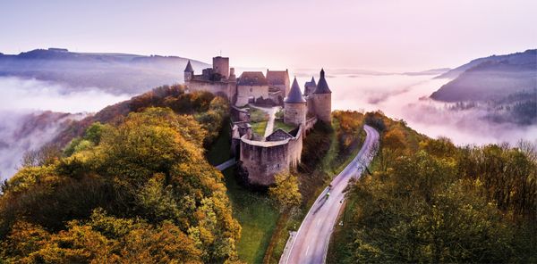
Head for the hills! Luxembourg too has dizzying ridge walks, spectacular cliffs, lush meadows, whispering forests and upland plateaus. The 52-kilometre-long Lee Trail in the north of the country is the first section of the long-distance Escapardenne Trail which crosses the border into Belgium. Three friends explored it together.

The three friends are keen hikers and love being outdoors. Alfonso Salgueiro, 49, is a freelance photographer who has been living in Luxembourg since 2001. Josh Dauphinee from Canada, 38, is doing the Lee Trail today for the first time. Ciarán Mackin, 36, from Ireland, is looking forward to getting to know the Lee Trail, which can be quite adventurous in places, with his friends. “We’ll see if I’m fit enough,” says Ciarán.

Lee Trail
© Alfonso Salguiero
Lee Trail
© Alfonso Salguiero

The three stages of the Escapardenne Lee Trail can be easily accomplished in three days by experienced walkers. So they sling their rucksacks on their backs and off they go. Disappear, leave behind their busy everyday lives, immerse themselves in an outdoor adventure in the Éislek.

First stage: postcard views and steep climbs

Ups and downs are the order of the day right from the start. After a croissant in Ettelbruck, the friends start the walk in a leisurely style, passing the memorial to the famous General Patton, a key figure in the Battle of the Bulge. Their destination for the day is Bourscheid-Moulin, where they intend to dine. As they walk through the quiet woods, climbing gently, the men get chatting. Josh always pursued a lot of outdoor activities in his native Canada. Ciarán, the Irishman, loves that there are so many forests in Luxembourg. “It’s not like that in Ireland,” he says. Then the men walk along in companionable silence again.
 

They enjoy the tranquillity of nature – and the climbs are getting steeper. Every so often, Alfonso stops, whips out his camera, sets up his tripod and snaps leaves, mushrooms, trees, tiny details and expansive views. An old-fashioned sign that fascinates Alfonso points the way to the “Priedegtstull” (pulpit in English) viewpoint, where St Willibrord is said to have preached to the faithful. From up here, they get their first picture-postcard view of the River Sûre as it winds through the green valley. After that, the Lee Trail continues to climb steeply, passing over a high plateau and then down again, past the village of Michelau. 

The next picture-postcard view comes at the end of this stage of the walk, a view of Bourscheid Castle from the Gringlee, the “green rock”. In Luxembourg there are lots of villages and place-names, especially in the north of the country and in the Mullerthal, which incorporate the word “lee”, meaning “rock”. Last stop: Bourscheid-Moulin. If you make a short detour to the campsite, you can enjoy another fine view of Bourscheid Castle towering over the landscape, with the Sûre in the foreground. Today there is a light mist hanging over the river. No wonder that the French writer Victor Hugo painted the castle in 1871 - castles, mist and romance go hand in hand!

Please make sure to enable your Cookies in case you don't see this content.

Second stage: Napoleon and the Finger of God

The second stage is probably the most strenuous part of the trail, covering over 19 km and climbing more than 900 m. Starting at the campsite, the hikers cross the railway line and walk across a steep slope, past the village of Bourscheid to the first spectacular stopping place, “Napoleonsbeemchen” (Napoleon’s Tree) on the high plateau, also called “Napoleonsknäppchen” (Napoleon’s Mound). The wind whistles around the plateau, because, apart from the tree and the viewing platform, there is nothing to stop it. The original tree was planted in 1811 in honour of the Emperor Napoleon, but it was felled by the Nazis in 1940. In 1941, the people of Bourscheid secretly planted a new tree – the lime that still stands there today. Alfonso and Ciarán gaze into the distance. The sprawling view is amazing, with fields and meadows creating a picturesque tapestry.
 

Back in the forest, they focus on the walk again: it’s a steep climb, with safety barriers in places and you have to watch where you put your feet. The path takes them on past the Rouschtert viewpoint to the “Doigt de Dieu”, a rock that is supposedly shaped like the finger of God. Alfonso is glad to have his wide-angle lens, so he can fit the whole of the unusual feature into his photo. Meanwhile, Josh lies in the shade of the “finger”, and Ciarán considers with a grin which of God’s fingers it might be and what God is trying to tell hikers with it. The three friends are a bit out of breath by now, but still in good humour. Josh gets up and climbs a little way up the rock below the finger. It looks dangerous, but he comes back safe and sound.

Lee Trail
© Alfonso Salguiero

The next viewpoint is another peculiar geological formation. The crumbling layers of slate are like puff pastry. If you scramble over them, you come to the Molberlee: a narrow, 500-metre-long path along a ridge, with the bare rock falling away steeply on either side. The Luxembourg Ardennes at their best. Many different species, some of them rare, grow around the Molberlee, including blueberries, called “Molbier” in Luxembourgish. They gave the ridge its name. Again, the men enjoy the peace and quiet – until a mountain biker whizzes past. So thrill-seekers come here too... The second stage finishes in the village of Hoscheid.

Please make sure to enable your Cookies in case you don't see this content.

Third stage: sound trail and thirsty work

From Hoscheid to Kautenbach, it’s just 15 km. There’s a special highlight here for children and the young at heart: the “Klangwee”, a themed sound trail with 17 different stopping points. It begins in the centre of the village. Some of the objects can be played with sticks, whether borrowed or improvised out of pieces of wood. Josh and Ciarán have great fun at the very first stop: if you hit the flat metal shape hard, it makes all kinds of crazy sounds – electronically. It even plays a German hiking song, which is very appropriate. There are also some more contemplative sound games, such as an impressive wooden structure, at the top end of which a wind chime moves gently. It’s very meditative. You also see families with children here, because you can walk the 6 km Klangwee separately from the Lee Trail. 

Alfonso, Josh and Ciarán leave the instruments behind and the Lee Trail takes them on through the Schlinder valley. Here they find St Michael’s chapel, which has an air of romantic solitude – as does the ghost village of Oberschlinder, where no one lives any more. There used to be 20 houses, but now only two remain, and the last residents moved away in 1948 – after the privations of the Second World War. Even before the Battle of the Bulge, many of the residents had emigrated to the USA.
 

The third stage also lives up to expectations in terms of spectacular viewpoints. They have walked more than 50 km. Down below, a train goes by and stops at the station in Kautenbach – the end of the walk. Not much further now. The sun is going down, and they walk quickly down the hill.

Lee Trail
© Alfonso Salguiero

Practical information

  • Free parking at the railway stations in Ettelbruck and Kautenbach.
  • For train and bus services, see www.mobiliteit.lu.
  • Take a good supply of food and drink with you as there are not many places to stop for refreshments along the way.
  • The Lee Trail is on unsurfaced paths, with less than 20 per cent of the way asphalted, so you need to wear suitable walking clothes and comfortable boots.
Éislek Germany France
Leading Quality Trails – Best of Europe

Escapardenne Lee Trail

  • 1. stage from Ettelbruck to Bourscheid-Moulin: 17.8 km, Category: difficult
  • 2. stage from Bourscheid-Moulin to Hoscheid: 19.3 km, Category: difficult
  • 3. stage from Hoscheid to Kautenbach: 14.6 km, Category: moderate
  • 2,000 m of combined ascent and descent over 52 km
  • Stunning viewpoints
  • Certified as a “Leading Quality Trail – Best of Europe”
  • Outstanding landscapes
  • The signposts: a white wave on a blue background; the same as those on the Escapardenne Éislek Trail, signposted in both directions
Lee Trail Bourscheid
© Alfonso Salguiero
© Camping Kautenbach
Camping Kautenbach
Pets allowedWifiRestaurant
© Visit Éislek
Viewpoint Gringlee
Viewpoint Gringlee
Find out more
© Visit Éislek
Patton Monument Ettelbruck
Discover the Patton Memorial in Ettelbruck, an important place of remembrance. This monument honours General George Patton Jr, whose 3rd US Army liberated Ettelbruck in December 1944, stopping the invasion of the Wehrmacht during the Battle of the Bulge.
Find out more
© Visit Éislek
Molberlee
Molberlee, near Hoscheid, Luxembourg, is a captivating rocky ridge offering stunning views of the Schlinder valley. Recognized for its unique biodiversity, Molberlee is a designated forest reserve and natural monument.
Find out more
© Studio Frank Weber
free
with theLuxembourgCard
Bourscheid Castle
Explore the fascinating Bourscheid Castle, where history meets breathtaking natural scenery. The imposing castle towers majestically over the Sûre valley and invites you to travel back in time to a bygone era. An unforgettable excursion the rich history of Éislek.
Find out more